The first of our regular features focusing on thousands of years of Orcadian history sees writer and archaeology student Sigurd Towrie explore one of the lesser known sites in the islands.
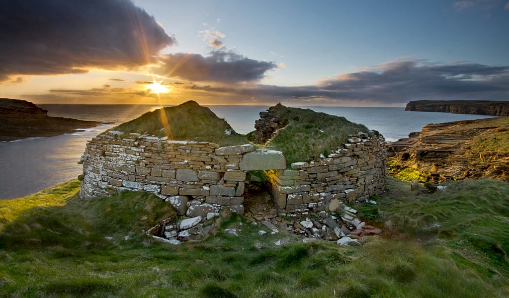
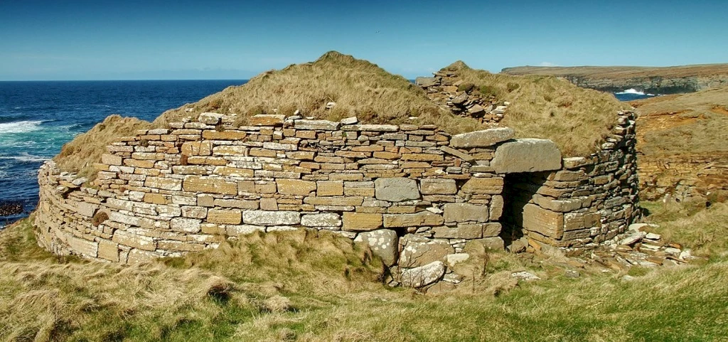
The word "broch" conjures up images of the massive towers found at Gurness, Midhowe and The Cairns in South Ronaldsay. Stunning though these are, it's a smaller, not-very-well preserved example that sits at the top of my list of favourite Orcadian Iron Age sites.
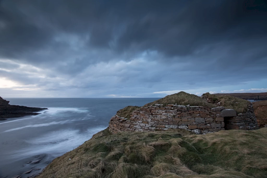
What the Broch of Borwick lacks in size it more than makes up for in location and atmosphere.
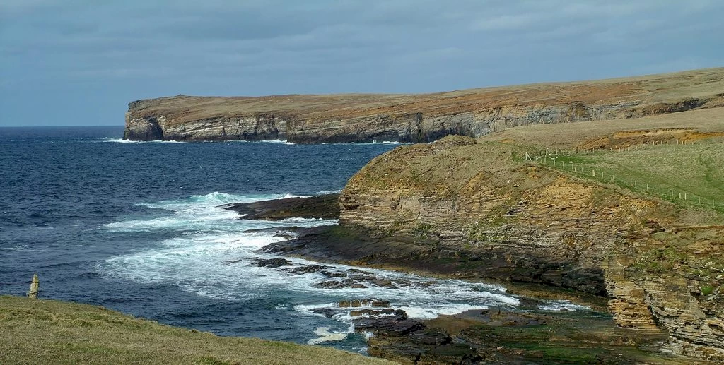
Perched atop an eroding headland in Sandwick, half a mile (as the crow flies) to the north-east of the Yesnaby car park, the broch takes its name from the adjacent bay, Borwick, which, unsurprisingly, was so called because of the broch - Old Norse "borg" meaning "fortification" and vik, "bay".
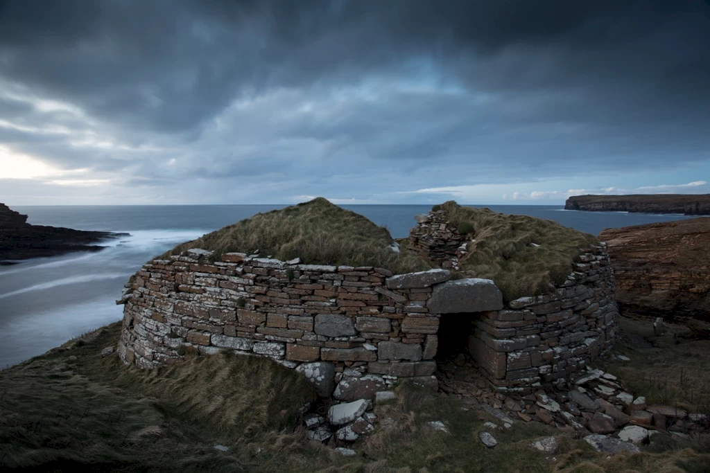
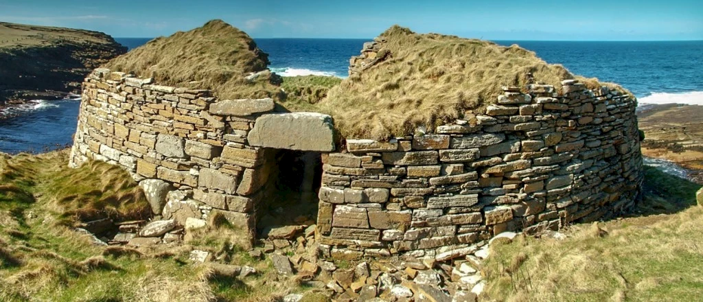
These days, the broch remains blend with the surrounding vegetation and the sheer cliff face below, making it difficult to spot when approaching from the opposite side of the bay - even if you know where to look. Climb the narrow track on the north side of the geo though and its landward wall and entrance, tucked behind a large bank, soon dominate the view.
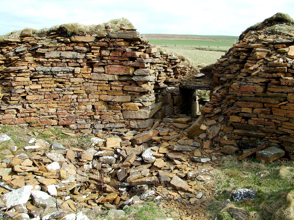
Access to the interior is by the original entrance. Inside you'll see that little remains of the western wall so take great care — there's not much between you and the precipitous drop to the rocks below.
The broch's ruinous state is due to a combination of erosion and stone robbing. Excavated in 1881 by William Watt, he not only exposed the structure to the fury of the elements but provided locals with a handy source of quarried stone. Within 50 years its walls were reduced from between 3.4 metres (11 ft) and 4.9 metres (16 ft) high to a mere 2.6 metres (8.5 ft) high.
Outside, Watt found a series of “out-houses”, of which little remains visible, save a few sections of masonry and walls.
The broch interior was filled with fallen masonry, as well as ash, bone and clay. Clearing this out, Watt suggested the building had seen two phases of use. It originally had a diameter of 7.3 metres (24 ft), but after going out of use, and was possibly ruinous, was reoccupied and modified. The new residents inserted another wall skin and subdivided the reduced 4.9 metre (16 ft) interior into compartments.
A 20th century re-evaluation of bone combs recovered by Watt suggests this secondary occupation took place between AD300-700.
The date the broch was built is not clear, but perhaps around 500BC. Back then it would have been a highly visible landmark, particularly from the sea. It is perhaps no coincidence that it towered above one of the few safe spots to come ashore between Warebeth, in Stromness, and the Bay of Skaill, in Sandwick.
Its size led to suggestions that it was home to a less-powerful individual, or family, or was perhaps merely a territorial marker or border keep. However, the idea that it was a diminutive example of a broch is a modern one, based on the scale of others such as Gurness and Midhowe. In fact, early accounts refer to Borwick as "large" and its dimensions were perhaps closer to the Iron Age norm and ideal for creating a strong base for a tall, stable construction.
Since its discovery much has been made of the broch's position in terms of defensibility. The idea that brochs were purely defensive structures, however, is one that has fallen out of favour.
Watt noted that the headland was cut-off by a 49-metre-long (160 ft) ditch that was between 15-18 metres (50-60 ft) wide and flanked by a nine-foot-high rampart (3-4 ft wide). The number of sea-worn round stones littering the exterior prompted him to suggest they were hurled ammunition used during sieges of the site.
While defence may have played a role in some brochs, with Borwick there is one major problem - why build a defensive structure on a clifftop location with your back to the sea? If the enemies are at the gate, and things are going badly, you have left yourself nowhere to run!
In addition, why construct a building that could be seen for miles? Particularly if you were concerned about a sea-borne threat? Instead, it may be that the construction of a broch was a means of highlighting your wealth and power in the most conspicuous way possible.
Addressing a meeting of Sandwick’s Mutual Improvement Association in 1906, the prolific parish "historian" George Marwick pointed out that the land around the broch had been cultivated "almost to the edge of the sea-crags" - a fact confirmed by recent archaeological work, which revealed substantial deposits of deliberately enhanced soil apparently relating to the broch.
So, rather than look at the Borwick broch as a poorer relative of other Orcadian sites, what we might have is actually a high-status Iron Age farmstead. As Marwick put it: "The ground on the western sea-coast was, it appears, cultivated with some degree of profit...than can be done nowadays."
Another element that may have influenced its location was the Iron Age penchant for incorporating underground structures into brochs. We can see this at Gurness and The Cairns with the so-called "wells" - subterranean chambers that appear to serve no practical purpose.
Directly beneath the Borwick broch is a cave known as Hell's Mouth (a suitably dramatic name that has nothing to do with the infernal realm but is a corruption of the Old Norse hellir, "cave"). Long before the broch was excavated, this cave was linked to the clifftop mound in local folklore. The grassy howe, as in most cases in Orkney, was thought to be the home of supernatural entities - in this case the "fair folk" or fairies.
According to Marwick, when he was a boy there was a track cut out of the face of the cliff, "so that a person ... could come up at the central building, by the way of the sea-cave."
At the lower end of the "fair folk's track", he wrote, was a "spot of very fine" dulse (edible seaweed) that was forbidden to eat. One old man told Marwick that, as a youth, he descended this track to gather some. He had taken but a mouthful when out from the cave came a large man. After following the lad for a while, the cave dweller returned to his abode where the old man was adamant that he could hear his fire-tongs rattling.
Marwick added: "When I first went into this cave its inner end was much higher. A hole, or cleft, appeared to run in an upward direction, on the side of which appeared to be steps, but we boys were terrified with (fairy) stories."
During excavations, Watt looked specifically for a connecting passage but found nothing. He conceded that the side of Hell's Mouth where it was possible there was an opening was "thickly coated in stalactites," adding that it was "more than likely that the occupants of the broch have had a passage communicating with the cave."
Although he was unable to locate an access to the cave, he did uncover an underground structure outside the broch that, on first glance, looked like a possible candidate. Investigation, however, revealed that narrow, low passage led eastward towards the external wall, where it appeared to have been filled by rubble from a collapse.
Because Watt didn't excavate further, the significance of this passage is unclear. However, given the known association with brochs and the subterranean structures known as souterrains, or earth-houses, there could be something similar at Borwick. The answer will only be revealed by future excavation.
The elusive cave passage appears to have been one of three ways of accessing the broch from the shore - all of which are now lost. The second, according to Marwick, was a "passage or stair" in the cliff to the west and another that reached the top "a little outside of the enclosing wall." A second, smaller, cave was situated half-way up the cliff and accessible by the latter path. Known as the "fairy hiding hole," it was, said Marwick, big enough to hide two men.
According to Marwick, he used these tracks regularly as a child but added that at the time of writing, they were now unsafe, due to the "corroding action of the sea and weather."
Little, if anything, remains of these tracks now and my last attempt to access the cave a few years ago ended up with a tumble on what I assume was the forbidden fairy dulse and a very damp trudge home. That said, there's still plenty to see and do at the site - from spectacular sea views and birdlife to the awe-inspiring cliffs leading northwards towards the Head o' Rowe.
So, next time you're planning a trip to Yesnaby, head north instead. I guarantee you'll be glad you did.
Sigurd runs the Orkneyjar website, full of information on Orkney history, places and folklore. You can also find him on Instagram.